Four Cities Forecast: Greece (May 10, 2011)

As if Greece didn't have enough problematic issues. Economic problems and the Eurozone. Out-of-control wildfires. Today's credit rating downgrade. And of course, earthquakes. As most geologists and seismologists know, Greece is situated near the collisional boundary of the African and the Aegean Sea tectonic plates. Major earthquakes have occurred throughout Greek history, causing major damage and loss of life.
Construction practices in ancient times led to an abundance of historic buildings of unreinforced masonry construction, the type most vulnerable to earthquake damage. For example, on July 9, 1956, a magnitude M7.8 earthquake occurred resulting in a tsunami that affected the entire Aegean sea. At least 4 major events have occurred since the M6.0 earthquake on September 7, 1999, including the M6.8 event on January 8, 2006 in southern Greece near Kythira.
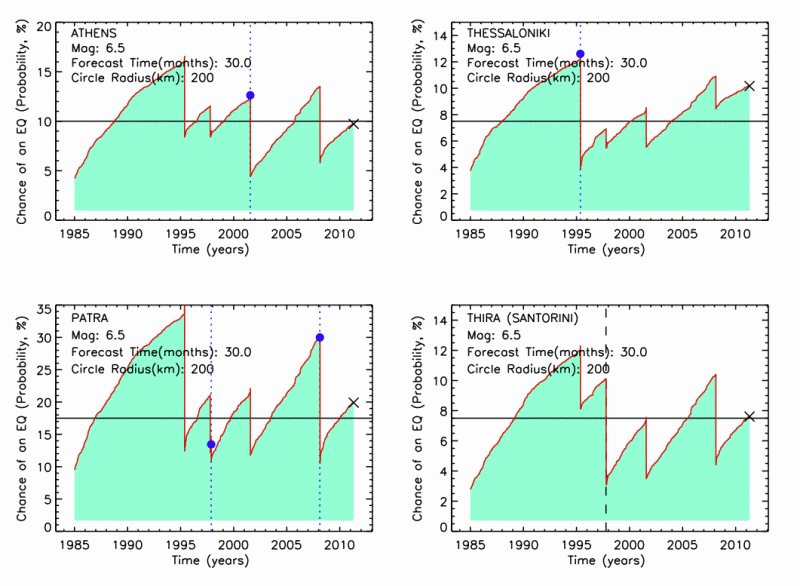
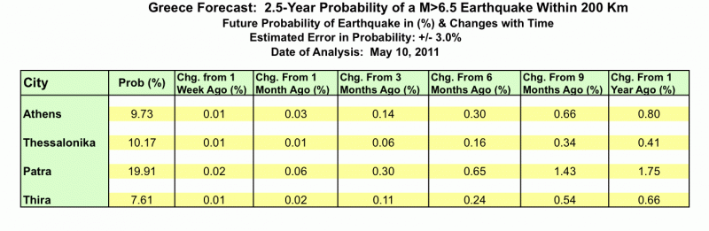
With this as background, we present here another Four Cities forecast for Greece, including the cities of Athens, Thessalonika, Patra, and the island of Thira (Santorini), whose volcanic explosion may have been the origin of the Atlantis legend. This forecast is for events having magnitudes M>6.5, within 200 Km radius and less than 40 Km depth, and for a time interval of 30 months (2.5 years) from the present.
Below is the timeseries plot of chance of an earthquake as a function of time. As before, the blue dots and blue dotted lines represent M>6.5 earthquakes that have occurred within the region of interest. The black dotted lines represent the time of M>6.5 earthquakes that have occurred near, but not in, the region of interest, and serve as reference values for the probability calculations in the region. More detailed discussions can be found in previous blogs.
 Tabular data are below.
About OpenHazards Bloggers
 Steven Ward is a Research Geophysicist at
the Institute of Geophysics and Planetary Physics, UC Santa Cruz. He specializes in the quantification and simulation of
natural hazards. Read Steve's blog.
Steven Ward is a Research Geophysicist at
the Institute of Geophysics and Planetary Physics, UC Santa Cruz. He specializes in the quantification and simulation of
natural hazards. Read Steve's blog.
 John Rundle is a Distinguished Professor of Physics
and Geology at UC Davis and
the Executive Director of the APEC Collaboration for Earthquake Simulations. He
chaired the Board of Advisors for the Southern California Earthquake Center from 1994 to 1996. Read John's blog.
John Rundle is a Distinguished Professor of Physics
and Geology at UC Davis and
the Executive Director of the APEC Collaboration for Earthquake Simulations. He
chaired the Board of Advisors for the Southern California Earthquake Center from 1994 to 1996. Read John's blog.