Floods
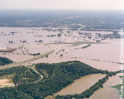
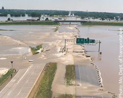
Two photographs of the July 1993 Missouri River flood, taken north of Jefferson City.
In addition to the danger of drowning, floods also create severe secondary problems. Typically, transportation to flooded areas is compromised, limiting the efforts of rescue crews. Additionally, flooding often contaminates water sources with sewage, which can create clean water shortages and outbreaks of disease for months after the waters subside. In the long run, lost crops and buildings may severely affect the local economy.
In the U.S., the areas most at risk for flooding are identified and mapped by the Federal Emergency Management Agency (FEMA). Properties within a Special Flood Hazard Area have a 1% or greater annual chance of flooding. In other words, they are expected to flood at least every hundred years. The 1-percent-annual-chance floodplain is referred to by some agencies and publications as the base floodplain or 100-year floodplain. To find out if you live in a Special Flood Hazard Area, use our Hazard Viewer.
Flooding and Earthquakes
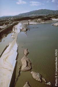
The Van Norman Dam after the 1971 San Fernando Earthquake.
There are also historical examples from the United States. The 1971 San Fernando Earthquake, for instance, significantly damaged the Van Norman Dam, which precariously held back 15 million tons of water from the densely populated San Fernando Valley below. Worried authorities evacuated tens of thousands of valley residents and then proceeded to lower the water level in the reservoir over the course of three days, effectively reducing the danger and the pressure on the fragile dam remains[2]. As a result of this narrowly averted disaster, California law requires all dam owners to file dam inundation maps with the California Emergency Management Agency. Other states, too, provide similar resources to assess the risk of flooding from a ruptured dam. These maps are the basis for our dam inundation mapping in the OpenHazards Hazard Viewer. While modern dams in seismically active areas are generally built to withstand significant earthquakes, all residents in dam inundation zones should be aware of their potential risk and evacuation routes.
[1] “Japan's Killer Quake: An eyewitness account and investigation of the epic earthquake, tsunami, and nuclear crisis.” Aired February 29, 2012 on PBS. http://www.pbs.org/wgbh/nova/earth/japan-killer-quake.html (Retrieved 8/15/2012).
[2] “The Los Angeles Dam Story.” USGS. http://earthquake.usgs.gov/learn/publications/la-damstory/ (Retrieved 9/3/2012).
Poll


| 1. | Tokyo | 68 |
| 2. | Los Angeles | 25 |
| 3. | Manila | 18 |
| 4. | Bandung | 17 |
| 5. | Santiago | 16 |
| 6. | Nagoya | 9.4 |
| 7. | Osaka | 9.4 |
| 8. | Jakarta | 9 |
| 9. | Lima | 8 |
| 10. | Chengdu | 7.5 |